
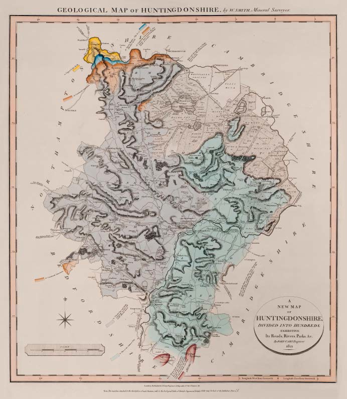
GEOLOGICAL MAP OF HUNTINGDONSHIRE, by W.SMITH, Mineral Surveyor
First published in Part V of A New Geological Atlas of England and Wales…1822 with Nottingham, Leicester and Rutland.
Map dated 1821 in the cartouche but according to Phillips (1844) Part V was not published until 1822.
Stratigraphy
Alluvial Chalk Flints, and other Stony fragments, mixed with Clay occupying the place of the Blue Golt or Brickearth of Cambridge
8 & 10 Brown Sand of Bedfordshire, in its course north-eastward through this and the adjoining County, obscured by Clay mixed with alluvial Chalk and Stone.
11 Place of the Oaktree Clay
14 Clunch Clay and Shale extensively covered with small alluvial Gravel.
16 Cornbrash Limestone, the first Quarry Stone used on the Roads North of London. / Cornbrash Limestone
18 Forest Marble, Clay &c of Atwalton Lynch
20 Upper Oolite Rock
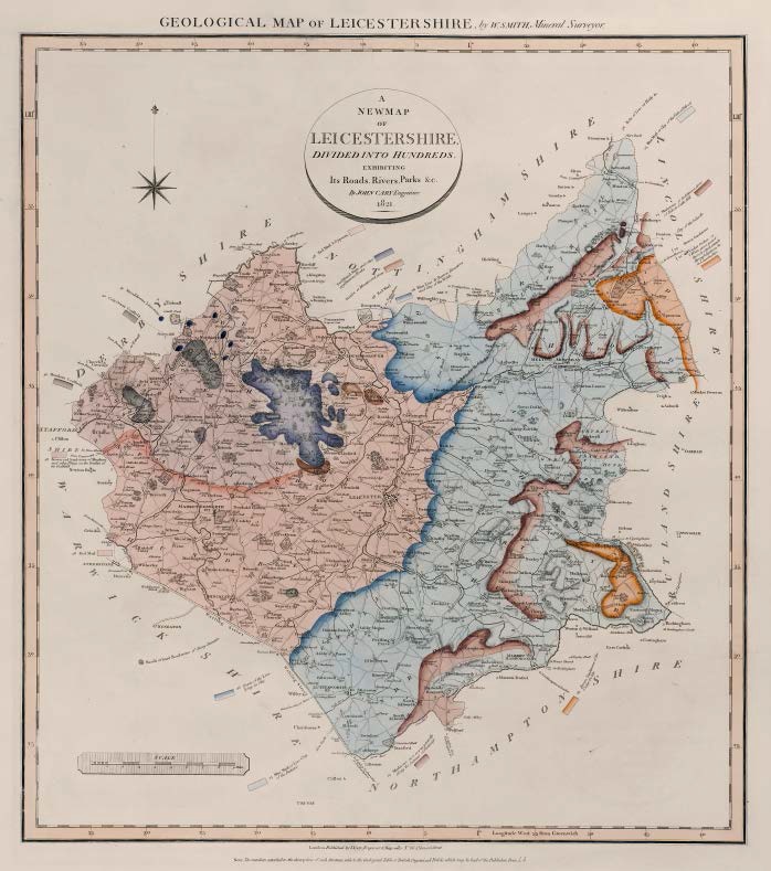
GEOLOGICAL MAP OF LEICESTERSHIRE, by W.SMITH, Mineral Surveyor
First published in Part V of A New Geological Atlas of England and Wales…1822 with Nottingham, Huntingdon and Rutland.
Map dated 1821 but according to Phillips Part V was not published until 1822.
Stratigraphy
22 Under Oolite or Whitestone, part of the rock which extends through Kesteven &c. in Lincolnshire.
23 Brown Sandstone / Brown Sandstone of the Under Oolite Clay of the hillside
24 Marlstone or Red-brown stone of Belvoir Castle Hill / Marlstone in a course generally along the Summit of Drainage
25 Blue Marl or Clay of the Vale of Belvoir / Blue Marl or Lias Clay of the Pastures
26 Beds of Lias at Harby &c. / Blue Lias or Barrow Limestone and Clay of the Wolds / Course of the Lias lying in Clay
28 Red Marl / Red Marl & Gypsum / Brown-red Sandstone of Measham and other Places on the borders of the Coalfield
30 Cole Orton Coalfield / Measham Coalfield
31 Metalliferous Limestone
Basalt or hard Road-stone of Stony Stanton
Swithland Slate and other argillaceous Rocks
Sienite or Mountsorrel stone
")
Description of the atlas counties from: A Memoir to the Map and Delineation of the Strata of England and Wales with part of Scotland
by William Smith (1815)
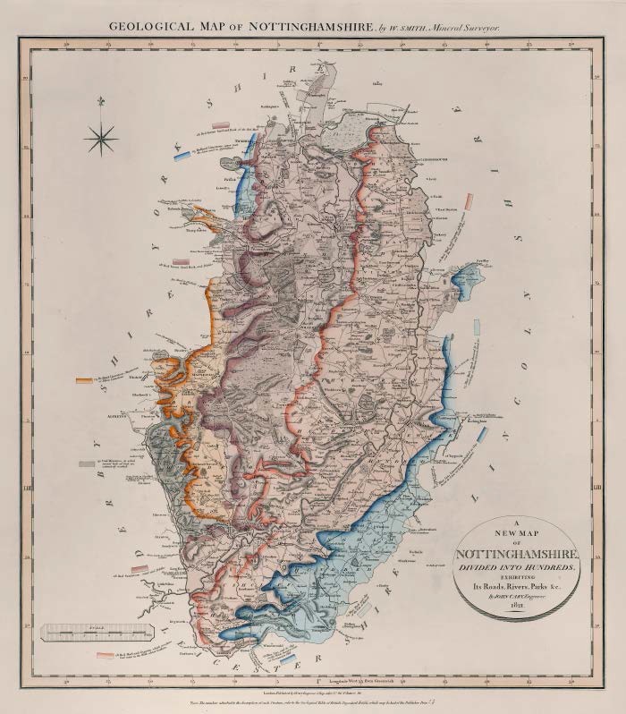
GEOLOGICAL MAP OF NOTTINGHAMSHIRE, by W.SMITH, Mineral Surveyor
First published in Part V of A New Geological Atlas of England and Wales…1822 with Leicester, Huntingdon and Rutland Maps dated 1821 but according to Phillips, Part V was not published until 1822.
Stratigraphy
25 Blue Marl, and Clay of the Vale of Belvoir / Blue Marl, much obscured by a covering of Alluvial Gravel, Sand, &c
26 Blue Lias Limestone, imbedded in Clay, burnt to Lime at Long Bennington. / Blue Lias, and its Clay on the Wolds, burnt to Lime at Normanton Hill.
28 Red Marl and Gypsum, which extends over the North and South Clays. / Red-brown Sand and Rock, of the Red Marl / Red-brown Sand Rock, and pebbles / Red Sandstone, Sand and Pebbles / Red Marl and Gypsum, which produces bad water in the Wells about Gotham.
29 Redland Limestone, upper part the Lime used in Agriculture / Redland Limestone, Magnesian or Yellow Limestone
30 Coal Measures, in which several beds of Coal are extensively worked.
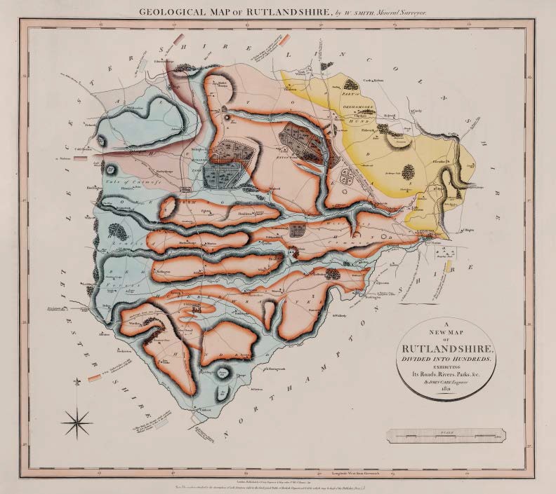
GEOLOGICAL MAP OF RUTLANDSHIRE, by W.SMITH, Mineral Surveyor
First published in Part V of A New Geological Atlas of England and Wales…1822 with Nottingham, Leicester and Huntingdon.
Map dated 1821 in cartouche, but according to Phillips, Part V was not published until 1822. No date given in text below lower engraved border.
Stratigraphy
20 Place of the Upper Oolite or Freestone Rock, quarried at Barnoak
21 Fullers Earth Rock and Clay, North of Stamford
22 Under Oolite, or inferior calcareous Freestone Rock, which produces a dry Stony Soil called Stonebrash
22 & 23 Under Oolite or white & brown stone of the hills
24 Marlstone
25 Blue Marl and Lias Clay / Blue Marl, the Stratum which produces the best Pastures in this & the adjoining Midland Counties
")
Description of the atlas counties from: A Memoir to the Map and Delineation of the Strata of England and Wales with part of Scotland
by William Smith (1815)
