
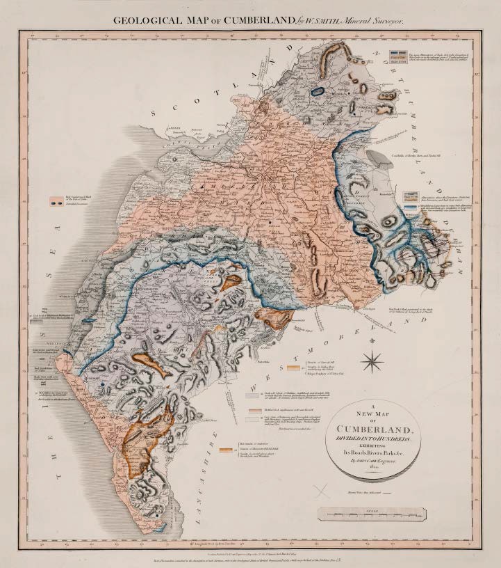
GEOLOGICAL MAP OF CUMBERLAND, by W.SMITH, Mineral Surveyor
First published in Part VI of A New Geological Atlas of England and Wales…1824 with Durham, Northumberland and Westmoreland.
Map dated March 1st. 1824
Copies known dated 1831
Stratigraphy
Red Sandstone & Marl of the Vale of Eden. Detached Limestones.
Red Sandstone of St Bees
Limestone sunk through for Coal at Preston How
30 Coal field of Whitehaven, Workington &c. Some Coal worked below the level of the Sea.
Shale Grit with some Coal above the Limestone
31 Metalliferous Limestone underlaying the Coalfield. Red Iron ore in this Rock near Cleator.
[In northeast]
Lime. Coal. Coarse Grit. Shale & Grit. The same Alternations of Shale, Grit rocks, Limestone & thin Coals as in the adjacent part of Northumberland which are much obscured by Peat and alluvial pebbles.
[In east]
Coal. Shale & Grit. Coarse Grit Alternations above the Limestone. Shale Grit, thin Limestone and bad Coal seams.
31 Metalliferous Limestone in many beds alternating with Grit and Shale, very productive of Lead Ores. Many fine waterfalls over Limestone beds.
33 Dark soft Schist of Skiddaw, Saddleback and Grisdale Fells in which the Lakes Derwent, Bassenthwaite, Buttermire & Crummock are situate It contains Lead, Copper Blende and other Ores.
Mottled Red argillaceous rock near Keswick
33 Grey slate of Buttermire and Borrowdale, associated with Hornstone, amygdaloid & argillaceous Porphyry Characterized by bold towering Crags. Produces Copper and Lead Ore.
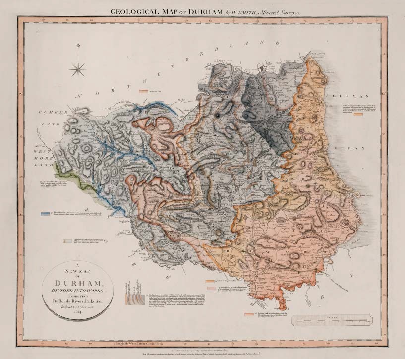
GEOLOGICAL MAP OF DURHAM, by W.SMITH, Mineral Surveyor
First published in Part VI of A New Geological Atlas of England and Wales…1824 with Cumberland, Northumberland and Westmoreland.
Map dated March 1st. 1824
Copies known dated 1831
Stratigraphy
Basalt or Great Whin Sill in lofty ranges from Caldron Snout, down the south side of the Tees. At High force it rests on dark Limestone.
28 Red Sand rock along the Banks of the Tees. The sulphurous water of Middleton found by boring in this Rock.
28 Red & Bluish Clay with alluvial matter extending to the summits of drainage above the Magnesian Limestone
29 Yellow or Magnesian Limestone / Yellow or Magnesian Limestone often dusty, sometimes brecciated, and at Building hill, in imitative concretions presents lofty cliffs against the Sea. Sunk through for Coal at Hetton lehole and Ferryhill.
30 Coalmeasures consisting of Shale & Grit rocks with numerous seams of Coal the prime Coal for London is obtained from a tract two to four miles wide ranging across the Tyne & Wear southeastward to and under the Magnesian Limestone. Around Durham dusty bad Coal. At West Pits and Thornly Pithouses in the lowest part of the Series, excellent Coal. Muscle-band Ironstone at Prudhoe __ The principal Grit rocks are marked by various shades of brown. The situations of the principal Collieries are marked by a dark Alluvial matter abounds in the eastern part of this Coalfield.
Millstone Grit
Alternations between the Limestone and Millstone Grit, consisting of Shale grit thin Coal seams and a thin Lime.
Metalliferous Limestone beds causing many waterfalls on the branch streams. Lead mines abundant in Wear dale and Tees dale.
")
Description of the atlas counties from: A Memoir to the Map and Delineation of the Strata of England and Wales with part of Scotland
by William Smith (1815)
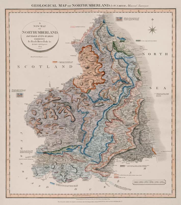
GEOLOGICAL MAP OF NORTHUMBERLAND, by W.SMITH, Mineral Surveyor
First published in Part VI of A New Geological Atlas of England and Wales…1824 with Cumberland, Durham and Westmoreland.
Map has imprint March 1st. 1824.
Copies known dated 1831.
Stratigraphy
Basalt in high cliffs North of Belford
Basalt along the Roman Wall presenting a bold escarpment to the North Overlaid by Limestone.
Red Marl & Sandstone
29 Magnesian Limestone
30 Coal measures or Series of Strata containing superior seams of Coal. Muscle-band Ironstone at Prudhoe. / Coalmeasures or Series of Strata containing inferior Seams of Coal.
Coal Lime Coarse Grit Shale & Grit Alternating Shale and Gritstone with Limestone and Coal both extensively wrought to supply the Sth. of Scotland / Alternating Shale & Gritstone some resembling Millstone Grit with thin Limestone and Coal seams.
Grit Rock between the superior & inferior seams of Coal
Millstone Grit
Alternations between the Millstone Grit and metalliferous Limestone consisting of Shale Grit. Thin Limestone and Coal.
31 Metalliferous Limestone separated into many beds by interposed Grits and Shale __ Lead Ore abundant.
34 Porphyritic & Sienitic Rocks of the Cheviot Hills covered with Verdure.
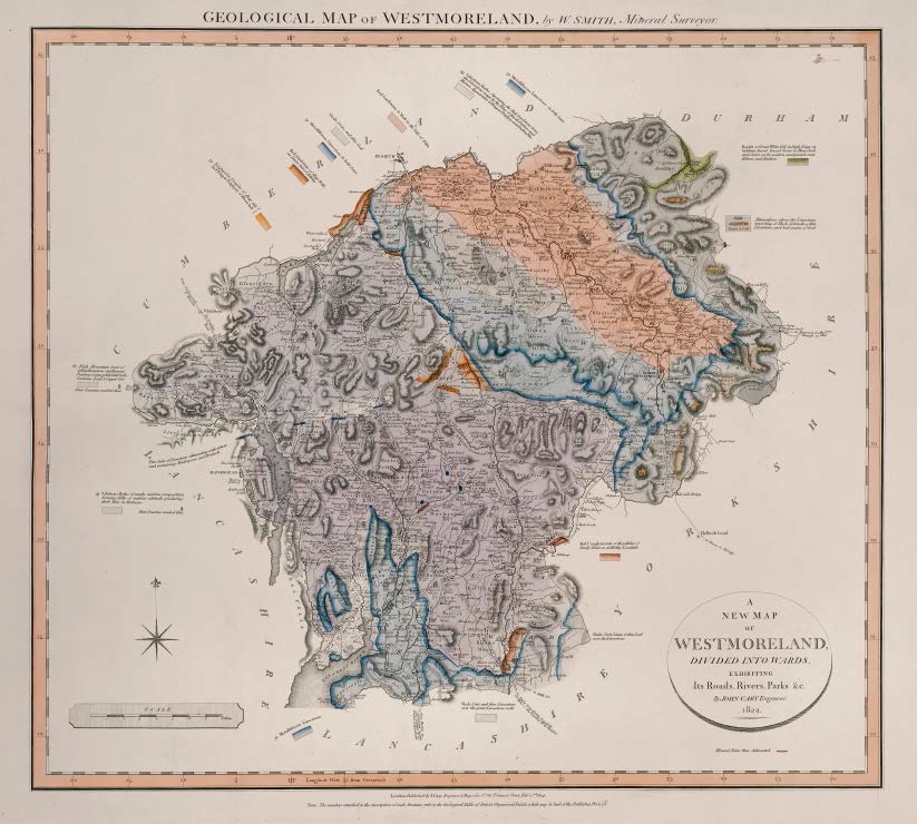
GEOLOGICAL MAP OF WESTMORELAND, by W.SMITH, Mineral Surveyor
First published in Part VI of A New Geological Atlas of England and Wales…1824 with Cumberland, Durham and Northumberland.
Map has imprint Feby. 2nd. 1824.
Copies known dated 1831.
Stratigraphy
Basalt or Great Whin Sill, in high Crags at Cauldron Snout, broad floors in Maizebeck and Scars on the western escarpment near Hilton and Dufton
Red Sandstone & Marl in the Vale of Eden
Red Conglomerate with pebbles of Sandy Schist as at Kirkby Lonsdale
Red Sandstone of Shap Wells at Dacre, full of Pebbles
Shale, Grits and thin Coal
Coal Coarse Grit Shale & Grit Alternations above the Limestone consisting of Shale, Gritrocks a thin Limestone and bad seams of Coal.
Shale, Grit and thin Limestone over the great Limestone rocks
31 Metalliferous Limestone in lofty Scars / Metalliferous Limestone in bold Scars / Metalliferous Limestone
33 Schistous Rocks of nearly uniform composition forming Hills of inferior altitude producing dark Slate in Kentmere
Thin beds of Limestone alternating with Schist and containing Madreporae and Producti
33 Schistous Rocks Separating the Red Sandstone from the Limestone range by the Pikes of Knock Dufton and Murton. Appearance of Felspar Porphyry near Dufton Pike / High Mountain tract of Schist Hornstone argillaceous Porphyry & amygdaloidal rocks Contains Lead & Copper Ore / Schistous Rocks of nearly uniform composition forming Hills of inferior altitude producing dark Slate in Kentmere
34 Porphyritic Granite of Shap fell Red felspar Porphyry of Hause hill.
")
Description of the atlas counties from: A Memoir to the Map and Delineation of the Strata of England and Wales with part of Scotland
by William Smith (1815)
