
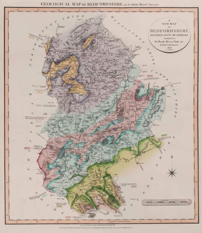
GEOLOGICAL MAP OF BEDFORDSHIRE, by W.SMITH, Mineral Surveyor
First published in Part III of A New Geological Atlas of England and Wales…1820 with Oxfordshire, Buckinghamshire and Essex
Map has imprint Feby. 1st. 1820.
Stratigraphy
Alluvial Clay containing rounded Chalk
2 4 Pebbles, Brickearth, & Sand, on Kensworth Beacon / Sand, Clay, Brickearth & Pebbles, the uppermost Strata of the Series in this County.
5 Chalk, Lower containing Tattenhoe Stone __ Upper abounding with Flints. / Chalk, Malm Land, lower Chalk upper Chalk with Flints on the higher Ground.
7 Blue Marl, Brickearth or Golt, of Cambridge identified by small transparent Belemnites see fig. 2 & 3 Strata identified.
8 & 10 Sand of the Portland Rock, producing near Sandy large Blocks of Carstone / Woburn Sand with Fullers Earth, the Sand of the Portland Rock
11 Oaktree Clay, 12 and 13 being here deficient and 11 and 14 much obscured by Alluvial Gravel, it is difficult to define the boundary of these Clays.
14 Clunch Clay & Shale, much obscured by Alluvial Gravel.
16 Cornbrash Limestone / Cornbrash, the lowermost Stratum of the Series exposed in this County.
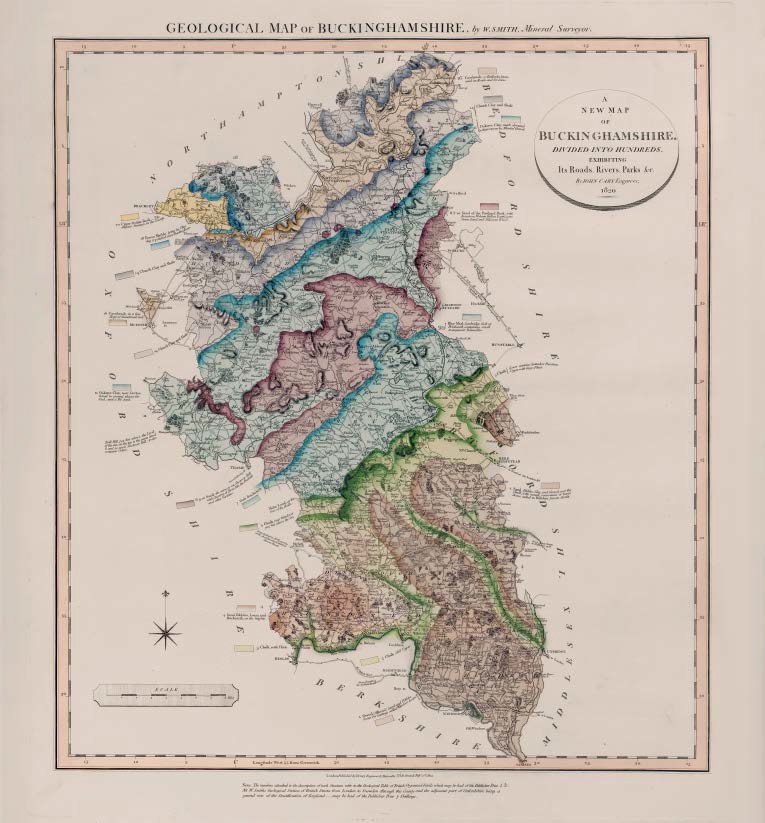
GEOLOGICAL MAP OF BUCKINGHAMSHIRE, by W.SMITH, Mineral Surveyor
First published in Part III of A New Geological Atlas of England and Wales… 1820 with Oxford, Berkshire and Essex.
Each map has imprint Feby. 1st 1820.
Below the engraved margin, in addition to a note referring to the Geological Table of British Organized Fossils is: NB W.Smith’s Geological Section of British Strata from London to Snowdon through this County and the adjacent part of Oxfordshire being a general view of the Stratification of England __ may be had of the Publisher Price 7 Shillings.
Stratigraphy
4 Sand, Pebbles, Clay, and Gravel, over the Chalk, with casual occurrences of large Stones, called in Wiltshire Sarcen Stones / Sand, Pebbles, Loam and Brickearth, on the heights / Gravel (Alluvial) Sand and Pebbles, Loam for Castings called Windsor Loam
5 Chalk Lower contains Tattenhoe Freestone Upper with large Flints. / Chalk, near Wendover 905 feet above the Sea. / Chalk, with Flints / Chalk, Cliff Upper
Malm Land at the foot of the Chalk
7 Blue Marl, Cambridge Golt or Brickearth, containing small transparent Belmnites. / Golt Brickearth
8 & 10 Sand of the Portland Rock, with Ironstone, Woburn Fullers Earth, some Green Sand, and Siliceous Wood.
8 9 10 Sand, the same as on Shotover Hill with Quarries of Stone like the Purbeck and other Varieties.
11 Oaktree Clay [and Clunch Clay and Shale] much obscured in their courses by Alluvial Gravel / Oaktree Clay, near Dorton bored in several places for Coal, and a Pit sunk.
14 Clunch Clay and Shale
16 Cornbrash, or Redbacks Stone, used on Roads and for Lime. / Cornbrash, in a fine Slope of Stonebrash Soil
18 Forest Marble, lying in Clay dug & polished near Buckingham
20 Upper Oolite Rock __ The deepest Stratum in the County.
Description of the atlas counties from: A Memoir to the Map and Delineation of the Strata of England and Wales with part of Scotland
by William Smith (1815)
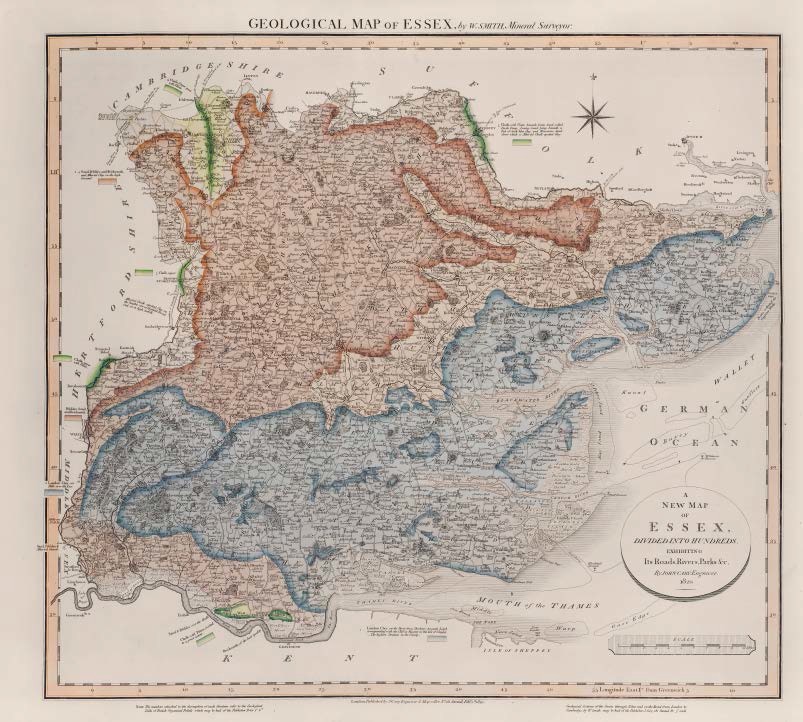
GEOLOGICAL MAP OF ESSEX, by W.SMITH, Mineral Surveyor
Geological map of Essex by W. Smith Mineral Surveyor. Published by J Cary Feb 1 1820
First published in Part III of A New Geological Atlas of England and Wales…1820 with Bedfordshire, Buckinghamshire and Oxfordshire. Map has imprint Feby. 1st 1820.
Bottom right, outside engraved border: Geological Sections of the Strata through Essex and on the Road from London to Cambridge, by W.Smith ____ may be had of the Publisher J.Cary, 181 Strand, Pr. 5s each
Copy (uncoloured) known dated 1826
Stratigraphy
1. London Clay, on Hills over the Lea. / London Clay, on the Shore from Shoebury towards Leigh corresponding with the Cliff at Minster in the Isle of Sheppey __ The highest Stratum in the County.
2 4 Sand, Pebbles and Brickearth, and Alluvial Clay on the high Ground.
5 Chalk, with Flints beneath Green Sand called Devils Dung __ Loamy Sand lying beneath a Bed of dark blue Clay and Micaceous Sand above which is Alluvial Chalk-spotted Clay. / Chalk Upper part with Flints / Chalk, upper / Chalk, upper with Flints / Chalk with Flints, worked to a great extent
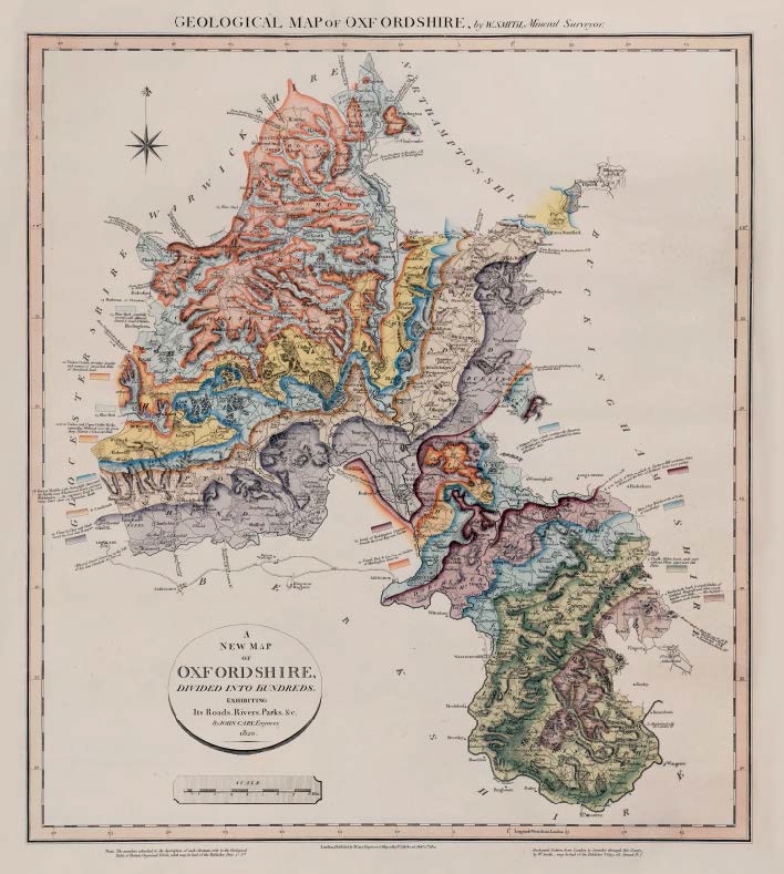
GEOLOGICAL MAP OF OXFORDSHIRE, by W.SMITH, Mineral Surveyor
First published in Part III of A New Geological Atlas of England and Wales…1820 with Bedfordshire, Buckinghamshire and Essex.
Map has imprint Feby. 1st 1820.
A copy is known dated in MS 1819 Copy known dated 1823
Stratigraphy
Alluvial Gravel, Common to the Vale of Isis from Clanfield to Oxford
2 4 Brickearth Sand & small Pebbles of Nettlebed Windmill and other woody heights over Chalk __ the highest Stratum in the County
5 Chalk, Malm Land, under part without Flints, upper part with Flints.
7 Blue Clay Brickearth or Golt
8 9 10 Sand of Woburn, which at Shotover Hill contains Ochre & Westward the beds of Portland Stone more perfect
11 Oaktree Clay, which overlays the Freestone of Heddington Quarries, identified by Ostrea deltoidea dele.
12 Coral Rag & Pisolite or Oolite of Heddinton Quarries
13 Sand of Heddington Common beneath Coral Rag and Pisolite
14 Clunch Clay and Shale, bored for Coal near Bampton
16 Cornbrash
18 Forest Marble, with Stonesfield Slates, used for Marble, near Whichwood Forest and near Bletchindon __ An expensive Trial for Coal many Years since on Ramsden Heath.
20 & 22 Under and Upper Oolite Rocks, expanding Westward over the Great Stony District of Cotswold Hills
22 Under Oolite, forming insular and ramose or intersected Hills of Stonebrash Land.
24 Marlstone or Ovenstone
25 Blue Marl / Blue Marl, partially covered with Alluvial Gravel & Sand & Pebbles
Description of the atlas counties from: A Memoir to the Map and Delineation of the Strata of England and Wales with part of Scotland
by William Smith (1815)
