
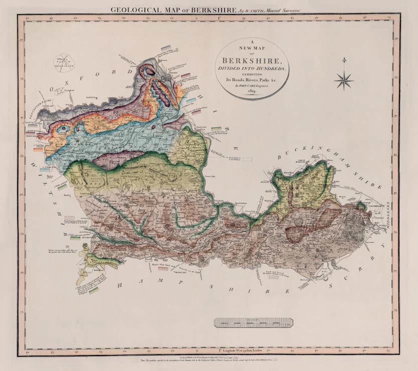
GEOLOGICAL MAP OF BERKSHIRE, by W.SMITH, Mineral Surveyor
First published in Part II of A New Geological Atlas of England and Wales…1819 with Gloucester, Surrey and Suffolk
Map has imprint Sept 1st 1819. Copies known dated 1821
Stratigraphy
Sand and Gravel. The highest Stratum in the County / Sand, Gravel and Brickearth, over the Chalk, as at Speenhill.
Plastic Clay Sand and Gravel, over the Chalk
5 Chalk / Lower Chalk, Firestone, &c above the Green Sand / Chalk, underpart / Chalk, upper part with Flints / Chalk, rising Southward abruptly to the high Ground of Inkpen Beacon 1011 feet above the Level of the Sea ___ The highest Ground in the Eastern and Southern parts of England.
6 Green Sand at & near Wantage
8 10 Sand of the Portland Rock
11 Oaktree Clay
12 Coral Rag & Pisolite / Coral Rag and Pisolite, found beneath the Clay in a late experiment for Coal.
13 Sand and Stone, beneath the Coral Rag at Kennington. / Sand and Sandstone
14 Clunch Clay & Shale ___The deepest Stratum in the County
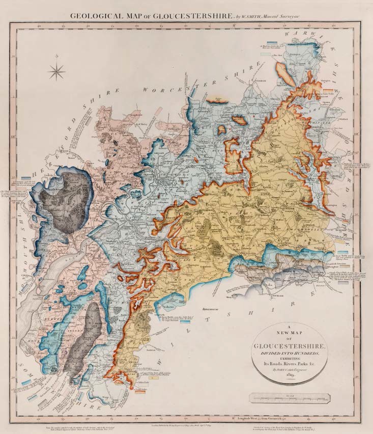
GEOLOGICAL MAP OF GLOUCESTERSHIRE, by W.SMITH, Mineral Surveyor
Geological map of Gloucestershire by W. Smith Mineral Surveyor. Published by J Cary Sept 1 1819
First published in Part II of A New Geological Atlas of England and Wales…1819 with Berkshire, Suffolk, and Surrey.
Map has imprint Sept 1st 1819.
Bottom right, outside engraved border: A Geological Section of the Road from London to Brighton, by W.Smith, to accompany this Work may be had of the Publisher J.Cary, 181 Strand, Pr. 7s .
Copies known dated 1821, 1831
Stratigraphy
14 Clunch Clay & Shale, in many places covered with gravel __ By the dark colour & other properties of this Stratum, many have been induced to expect and some to search for Coal hereabout. The highest Stratum in the County.
Kellways Stone, situated immediately beneath the Clunch Clay
16 Cornbrash Limestone
18 Forest Marble, some thin Shelly Beds of this Rock are used for Slates, the thicker for rough Pavements. / Forest Marble used for rough Paving and some polished for Hearths and Chimney Pieces.
20 Upper Oolite Rock, which contains the Beds of Bath and Box Freestone / Upper Oolite Rock, containing fine Calcareous Freestone
21 Fullers Earth
22 Under Oolite / Under Oolite Rock, Calcareous
24 Marlstone, or Ovenstone, the brown soft sandy Beds of this Rock being much used in the construction of Ovens.
24 & 25 Blue Marl Marlstone, Produces Bath Middle Hill and Cheltenham Waters
25 Blue Marl
26 Blue Lias, Crosses the Avon River into Warwickshire
26 & 27 Lias Limestone / Blue & White Lias, both used on the Roads, the Blue for Lime
26 Lias Limestone, above the Red Rock
Red Sand Stone, Rock at Redcliff
28 Red Marl containing Beds of Soft whiteish Sandstone / Red Marl, containing Gypsum. At Pucklechurch &c Coal Pits, Sulphate of Strontian, West of Bath at Stapleton and West of Clifton.
30 Coal, with the usual Argillaceous accompaniments and with micaceous Grit Stone Rocks which rising into high Hills on the borders of the Forest are wrought for Paving Stones, Steps, Cyder Mills, Grindstones, &c. / Coal, with Penant or Gritstone in Cliffs on each side of the Avon, wrought into Paving Stone, Steps, Rollers, &c.
31 Limestone, under the Coal containing beds of Iron-ore and Yellow Ochre in great abundance. / Limestone, in high cliffs on each side of the Bridge [at Chepstow] / Limestone, forming high romantic Cliffs on each side of the Avon__ The Hot Water Springs of Clifton are on the Shore of the River beneath the Cliff.
32 Red Rhab and Dunstone with brecciated Sandstone dug & used for Hearthstones of the Iron Furnaces. The deepest Stratum in the County
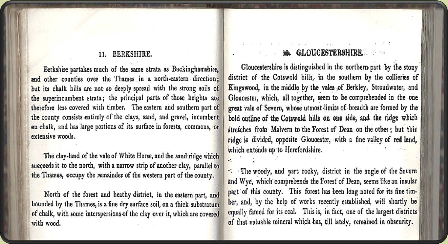
Description of the atlas counties from: A Memoir to the Map and Delineation of the Strata of England and Wales with part of Scotland
by William Smith (1815)
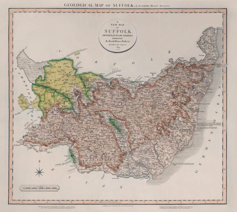
GEOLOGICAL MAP OF SUFFOLK, by W.SMITH, Mineral Surveyor
Geological map of Suffolk by W. Smith Mineral Surveyor. Published by J Cary Sept 1 1819
First published in Part II of A New Geological Atlas of England and Wales…1819 with Berkshire, Gloucestershire, and Surrey.
Map has imprint Sept. 1st. 1819.
Bottom right, outside engraved border: A Geological Section through Norfolk and Suffolk, by W.Smith, in illustration of this Map, may be had of the Publisher J.Cary, No. 181 Strand, Pr. 5s .
Copies known dated 1821
Stratigraphy
2 Clay, Cliff much undermined and washed away by the Sea the highest Stratum in the County.
Sand mixed with and overlaying the Crag drifted by the Wind __ The Crag contains loose Fragments of Shells which are found in numerous Pits at Thorpe Comn. near Woodbridge, Ipswich, Bentley, &c used for Manure.
3 Crag with Brickearth beneath & up the Deben River; containing Septaria, from which the Roman Cement is made. / Crag Stony, washed ashore quarried inland and used in Building, and lately by W.Smith’s advice burnt to Lime.
4 Sand over Chalk __ The light Sand Lands of Suffolk are called the Flock District./ Sand and gravel.
Clay on the high Ground containing rounded balls of Chalk.
Chalk Marl
5 Chalk, covered with Sand which drifts with the wind. A sand flood happened at Santon Downham. / Chalk, covered with a floor of Stratified Flint.
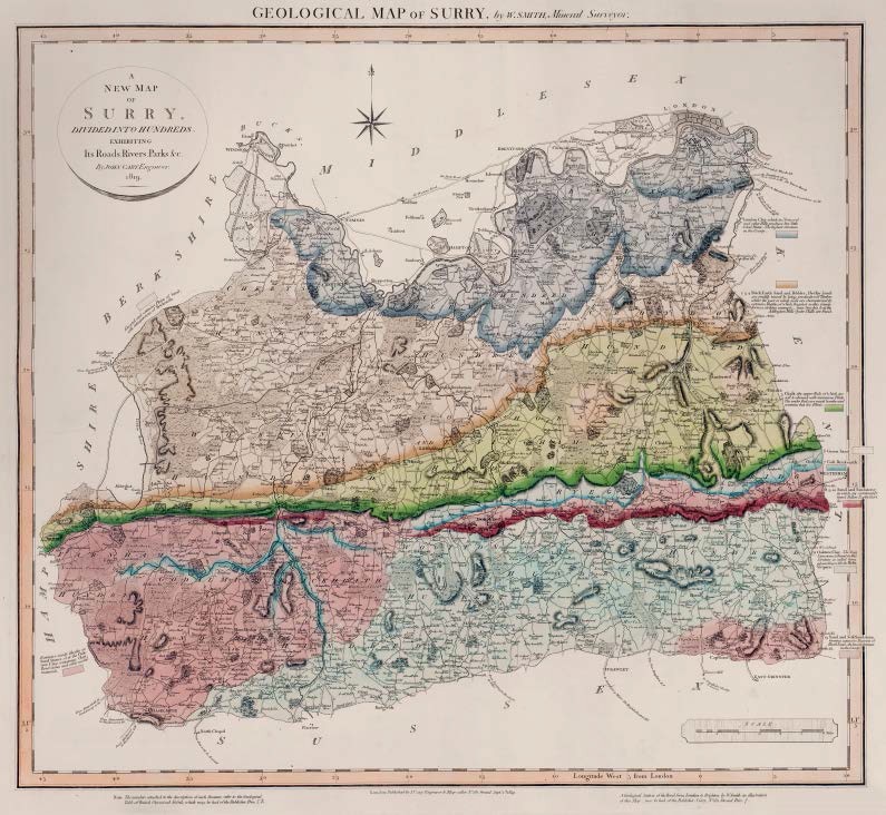
GEOLOGICAL MAP OF SURRY, by W.SMITH, Mineral Surveyor
Geological map of Surry by W. Smith Mineral Surveyor. Published by JCary Sept 1 1819
First published in Part II of A New Geological Atlas of England and Wales…1819 with Berkshire, Gloucestershire, and Suffolk.
Map has imprint Sept 1st 1819.
Bottom right, outside engraved border: A Geological Section of the Road from London to Brighton, by W.Smith, in illustration of this Map may be had of the Publisher J.Cary, No.181 Strand, Price 7s .
Copies known dated 1821
Stratigraphy
1 London Clay, which in Norwood and other Hills produces but little & bad water __ the highest Stratum in the County.
Elevated and extensive Plains of Sand, with interspersions of Brickearth.
2 3 4 Brick Earth Sand and Pebbles, The Clay Lands are readily traced by being productive of Timber, whilst the poor or sandy Soils are characterized by extensive Heaths, of which Bagshot in this County forms a striking example __near Croydon & at the Addington Hills Oyster Shells are found.
5 Chalk, the upper Beds of which are soft & abound with numerous Flints. The under Beds are much harder and contains but few Flints.
6 Green Sand
7 Golt Brickearth
8 9 10 Sand and Sandstone in which are commonly found Fullers Earth, Chert, &c.
Extensive Sandy heaths on Sand Stones, over the Oaktree Clay, containing Chert, Road-stones and other useful materials.
11 Oaktree Clay__ The Sneg Limestone is found in this Stratum so called from abounding with the Helix Vivipara.
13 Sand and Soft Sandstone forming extensive Districts of Heath Land __ the lowest Stratum in the County
Description of the atlas counties from: A Memoir to the Map and Delineation of the Strata of England and Wales with part of Scotland
by William Smith (1815)
