
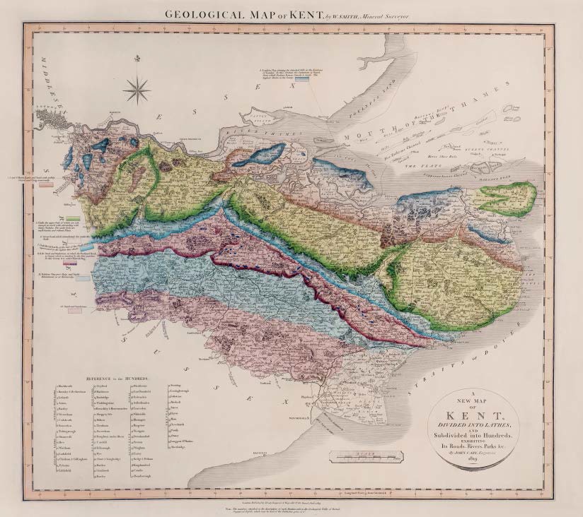
GEOLOGICAL MAP OF KENT, by W.SMITH, Mineral Surveyor
Geological map of Kent by W. Smith Mineral Surveyor. Published by J Cary 1819
First published in Part I of A New Geological Atlas of England and Wales…1819 with Sussex, Norfolk and Wiltshire
Map has imprint Jany. 1. 1819.
Stratigraphy
1. London Clay, forming the detached hills in the Environs of London. In this Stratum the Septarium is found, from which Parker’s Roman Cement is made. The highest Strata in the County.
2, 3 and 4. Brick Earth and Sand, with pebbly Gravel and Crag occasionally.
5. Chalk, the upper beds of which are soft enough to mark with, abounding with flinty Nodules. The under beds are much harder, and without Flints.
6. Green Sand, which immediately lies under the Chalk.
7. Golt Brick Earth, at the foot of the Chalk Hills represented by the lighter blue shade.
8, 9, 10. Sand and Sandstone, in which the Portland Rock is found, which is marked by the blue patches. In this County it is called Kentish Rag.
11. Oaktree Clay, part Slaty, and highly Bituminous, as at Kimmeridge.
13. Sand and Sandstone.
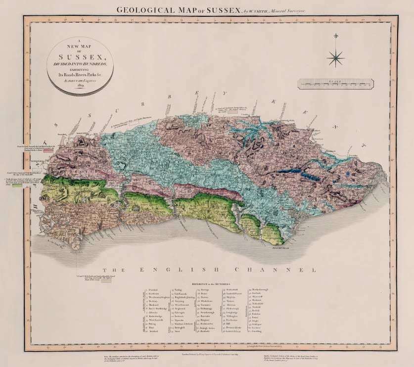
GEOLOGICAL MAP OF SUSSEX, by W.SMITH, Mineral Surveyor
First published in Part I of A New Geological Atlas of England and Wales…1819 with Norfolk, Kent and Wiltshire.
Map has imprint Jany. 1819.
Stratigraphy
2, 3 and 4. Brick Earth and Sand, with pebbly Gravel and Crag occasionally. The highest Strata in the County.
5. Chalk, the upper beds of which are soft enough to mark with, abounding with flinty Nodules. The under beds are much harder and without Flints.
6 and 7. Green Sand and Golt Brock Earth, at the edge of the Chalk Hills.
8 and 10. Sand, beneath the Golt Brick Earth, in the lower part of which in Dorsetshire, the Portland Rock is found.
11. Oaktree Clay, part Slaty, and highly Bituminous, as at Kimmeridge.
13. Sand and Sandstone, laying below the Oaktree The deepest Strata in the County.
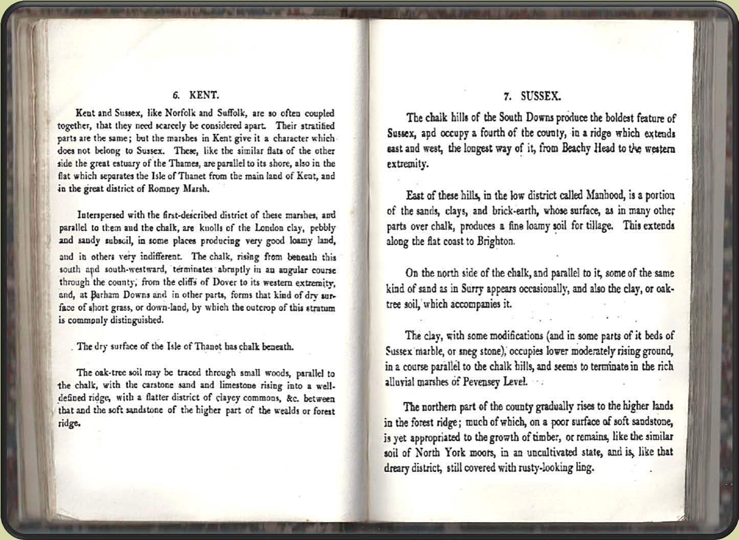
Description of the atlas counties from: A Memoir to the Map and Delineation of the Strata of England and Wales with part of Scotland
by William Smith (1815)
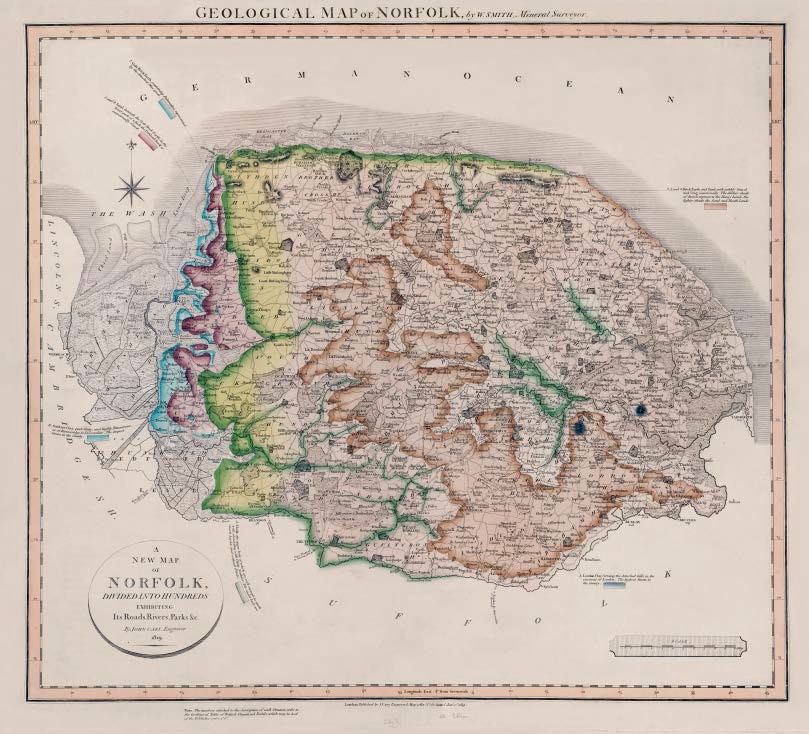
GEOLOGICAL MAP OF NORFOLK, by W.SMITH, Mineral Surveyor
First published in Part I of A New Geological Atlas of England and Wales…1819 with Sussex, Kent and Wiltshire.
Map has the imprint along the lower engraved border Jany. 1st. 1819.
Stratigraphy
1. London Clay, forming the detached hills in the environs of London. The highest Strata in the County.
2, 3 and 4. Brick Earth and Sand with pebbly gravel and Crag occasionally. The darker shade of Brown represents the Heavy Lands, the lighter shade the Sand and Heath Lands.
5. Chalk, the upper beds of which are soft enough to mark with, abounding with flinty Nodules. The under beds are much harder, and without Flints.
7. Golt Brick Earth, containing Belemnites, represented by the detached blue spots.
8 and 9. Sand, beneath the Golt Brick Earth in the lower part of which the Portland Rock is occasionally found.
11. Oaktree Clay, part Slaty, and highly bituminous, as at Kimmeridge in Dorsetshire. The deepest Strata in the County.
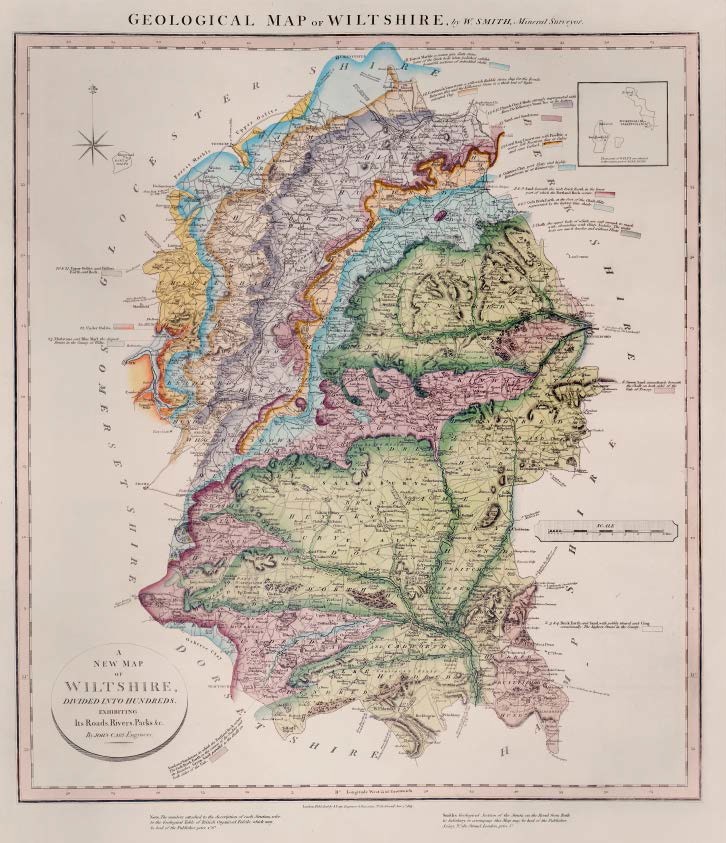
GEOLOGICAL MAP OF WILTSHIRE, by W.SMITH, Mineral Surveyor
First published in Part I of A New Geological Atlas of England and Wales…1819 with Norfolk, Kent and Sussex.
Map has imprint Jan 1st 1819
Bottom right, outside engraved border: Smith’s Geological Section of the Strata on the Road from Bath to Salisbury, to accompany this Map may be had of the Publisher J.Cary, No.181 Strand, price 5s .
Copy known dated 1831
Stratigraphy
2 3 & 4. Brick Earth and Sand, with pebbly Gravel and Crag occasionally. The highest Strata in the County.
5. Chalk, the upper beds of which are soft enough to mark with, abounding with flinty Nodules. The under beds are much harder and without Flints.
6. Green Sand, immediately beneath the Chalk on both sides of the Vale of Pewsey.
6 & 7. Golt Brick Earth at the foot of the Chalk Hills, represented by the lighter blue shade
8 & 9. Sand beneath the Golt Brick Earth, in the lower part of which the Portland Rock occurs.
Sand and Sandstone in which the Portland Rock occurs. The Golt Brick Earth in the course of the Nadder and its Branches. Green Sand parallel to the Chalk on both sides of the Vale.
11. Oaktree Clay, part Slaty and highly Bituminous, as at Kimmeridge.
12. Coral Rag Limestone, with Pisolite, a coarse soft Freestone, dug at Calne and near Oxford.
13. Sand and Sandstone
14 & 15. Clunch Clay & Shale, strongly impregnated with Alum. The Kellaways Stone lies at the bottom.
16. Cornbrash Limestone, a yellowish Rubble stone, dug for the Roads. Between this and the Kellaways Stone is a thick bed of light coloured Clay
18. Forest Marble, a coarse grey Slaty stone. Some of the thick beds when polished exhibit beautiful sections of imbedded shells.
20 & 21. Upper Oolite, and Fullers Earth and Rock.
22. Under Oolite
23. Marlstone and Blue Marl, the deepest Strata in the County of Wilts.
Description of the atlas counties from: A Memoir to the Map and Delineation of the Strata of England and Wales with part of Scotland
by William Smith (1815)
